Historic Preservation Commission OKs New District Boundaries
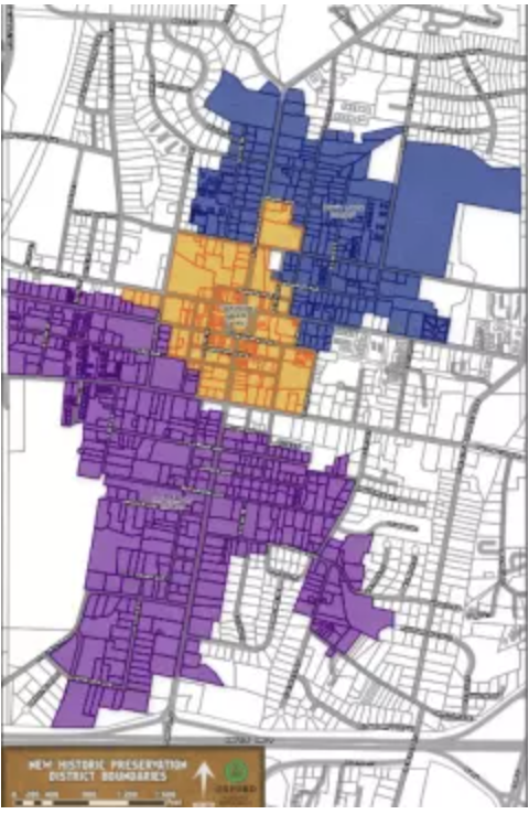
Proposed new district map.
By Alyssa Schnugg for HottyToddy.com
In an effort to align local historical districts with the National Historical Districts, the city of Oxford, in conjunction with the Mississippi Department of Archives and History, recently underwent a re-survey of Oxford’s local historic districts.
Now that the re-survey is complete, the number of districts that the Oxford Historic Preservation Commission oversees has decreased from five to three districts.
The new boundaries were presented to the Oxford Historic Preservation Commission on Monday during their regular meeting.
No new properties were added to the new boundaries; however, 62 properties were removed from the historic boundaries.
The changes proposed will more closely align Oxford’s local historic districts with the existing National Register districts.
“We wanted to align with the National District boundaries as it was creating a lot of confusion for property owners,” said Kate Kennwright, Historic Preservation Planner for Oxford.
Most of the removed properties were more recently built condos or other buildings that were not determined to contribute to the architectural, historic or cultural significance of the district in which the property is located.
All surveys in the existing districts were updated, and the consultant on the project, Judith Johnson & Associates, recommended changes to the existing local districts.
This work was completed with matching grant funds through the Mississippi Department of Archives and History.
The three recommended districts will include 642 properties.
The project also included the creation of a new GIS map which will be available to the public after the Board of Aldermen approves the proposed district boundaries.
Viewers will be able to search by address or photo to view all of the information about a specific property from the updated survey.
This was an effort to be more transparent with the community,” Kenwright said. “We hope that this will aid property owners, architects, engineers and realtors in exploring the history of the properties that they come into contact with or work on.”
The commission voted to recommend approval of the new boundaries to the Oxford Board of Aldermen.